
Berlin Wall – history of creation and destruction, photo, description, map
More than a quarter of a century has passed since the fall of the infamous Berlin Wall. Willy Brand, one of the German chancellors, called this building the “wall of shame”. The concrete fence became a symbol of the division of Germany into separate states and the Cold War – the time of confrontation between the two superpowers: the USSR and the USA.
Why did it take
The unconditional surrender of the Third Reich after the Second World War led to the redivision of the world into new spheres of influence. The strengthening of the positions of the USSR in Eastern Europe aroused the fears of the countries of the Western camp, which owned the idea of dividing the defeated power. In February 1945, the participants in the Yalta Conference (America, England, France and the USSR) determined the post-war status of Germany: the allies agreed on the dismemberment of the country. The question of the demarcation of the four occupation zones was finally resolved during the negotiations in Potsdam on 07/17-08/02/1945.
Four years later, in May 1949, a new state appeared on the world map – the FRG, and six months later – the GDR. The almost 1,400 km long border ran from Bavaria in the south to the Baltic Sea in the north. It cut through landscapes, settlements and the lives of millions of people. Berlin also turned out to be bipolar, while remaining a free zone. Residents moved without problems between the two parts of the divided city.
Walter Ulbricht, the leader of the GDR, was interested in stopping the ever-increasing outflow of citizens (especially valuable specialists) to the western side. He repeatedly addressed Khrushchev with letters about the need to strengthen control on the border with the FRG. The impetus for the construction of the fence was the political conflict of 1961. Its participants – the USSR and the USA – claimed undivided ownership of the city. The Vienna negotiations, the topic of which was the status of Berlin, were unsuccessful, and the Soviet leadership approved the proposal of the GDR to strengthen border control.
Construction history
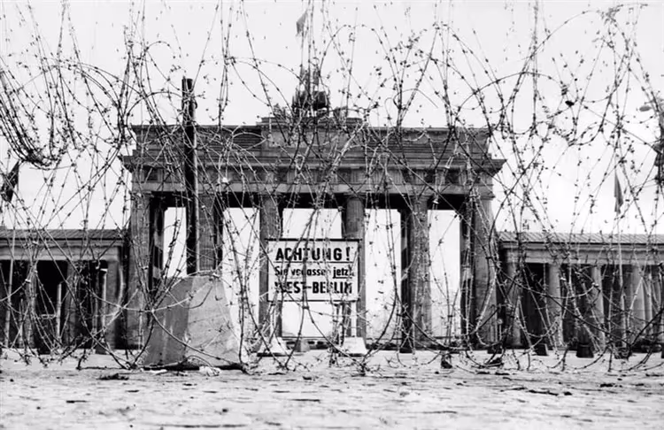
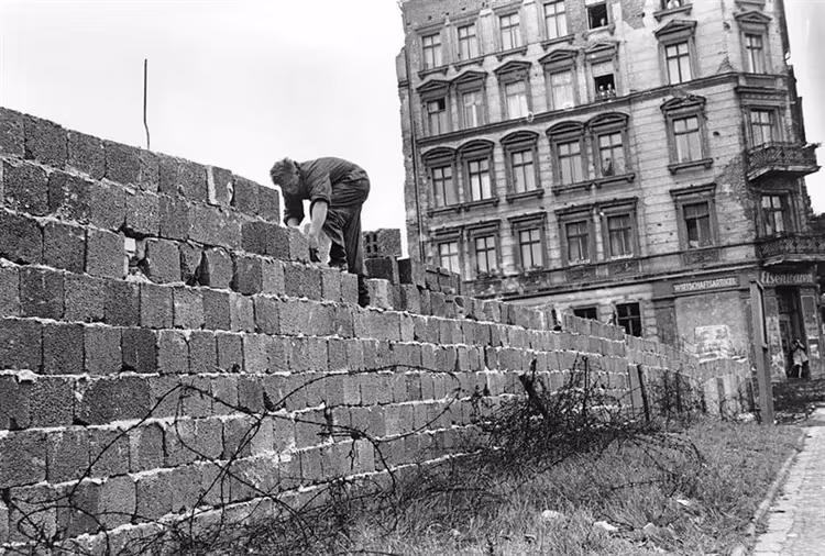
On the night of August 13, 1961, barbed wire appeared in the eastern part of the city. Further, the armed troops blocked the transport arteries and installed barriers. By August 15, the entire border line was cordoned off. The first blocks appeared. Creating a reinforced concrete structure, the builders blocked the streets, walled up the windows of nearby houses, cut the wires and welded the pipes. The wall knew no barriers – it passed through metro stations, tram lines, railway crossings and the Spree River.
The Brandenburg Gate located on the way was surrounded by a fence on all sides, making the main symbol of Berlin inaccessible to both western and eastern residents of the city. From 1962 to 1978, the building was completed and refurbished. Each time the wall took on more and more ominous outlines.
What was
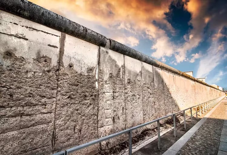
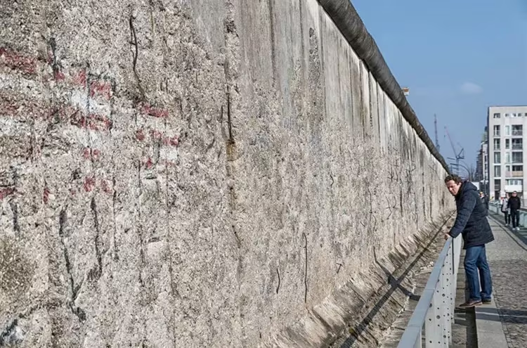
The Berlin Wall is an engineering structure 3.60 m high, consisting of reinforced concrete segments. From above, the fence was closed by iron pipes installed in 1975, which did not allow clinging to the edge of the fortification with hands. At the same time, to strengthen the protection at the foot of the structure, anti-tank hedgehogs and barrier tapes with spikes, popularly nicknamed “Stalin's lawn”, were installed. Several zones were supplemented with live barbed wire.
By the end of the 1970s, a metal mesh with signal flares was reinforced in separate sections on the eastern side. It was separated from the wall by an earthen ditch, called the “death strip”. This area was guarded by dogs and illuminated by powerful searchlights. An illegal attempt to move to the western part of the city was punishable by imprisonment or death.
The total length of the structure was 155 km, of which Berlin accounted for 44.75 km. The “shameful wall” crossed 192 streets, 3 highways and 44 railway lines. All along there were 20 bunkers, 302 towers and 259 posts guarded by guard dogs. 10,000 armed soldiers patrolled the defensive fortification, who were ordered to shoot to kill if necessary.
Border crossing
The odious construction divided the city and cut off relatives and friends from each other. Only pensioners were allowed to cross the border. Nevertheless, reckless refugees tried to find loopholes through which they could leave the “socialist paradise”. According to various sources, between 136 and 206 East Berliners died trying to escape, most of them within five years of the construction of the fence.
The first person killed was Günther Litfin, who was shot dead in August 1961 by GDR border guards while trying to get to West Berlin along the Spree River. In 1966, 40 shots killed two children. They were 10 and 13 years old. The last two victims were Winfried Freudenberg, who crashed on March 8, 1989, flying over the wall in a makeshift balloon, and Criss Gueffroy, who died in a hail of bullets while trying to cross the border in February of that year.
Fall and destruction
Mikhail Gorbachev, who came to power, began to modernize the state and government apparatus. Under the slogans “Glasnost” and “Perestroika” he reformed the Soviet Union. The leadership of the GDR lost the support of the USSR and could no longer stop its citizens seeking to leave the country. Socialist Hungary, followed by Czechoslovakia, liberalized the border regime. Residents of East Germany filled these states, wanting to get to the FRG through them. The Berlin Wall was no longer needed.
In fact, the beginning of the fall of the wall was the evening of November 9, 1989. At a live press conference on the decision of the authorities to open checkpoints, the question was raised when this decision would come into force. In response, a member of the Politburo of the Central Committee of the Socialist Party of Germany, Schabowski, uttered the famous words: “It will happen, as far as I know… now, immediately.”
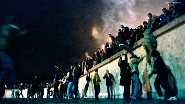
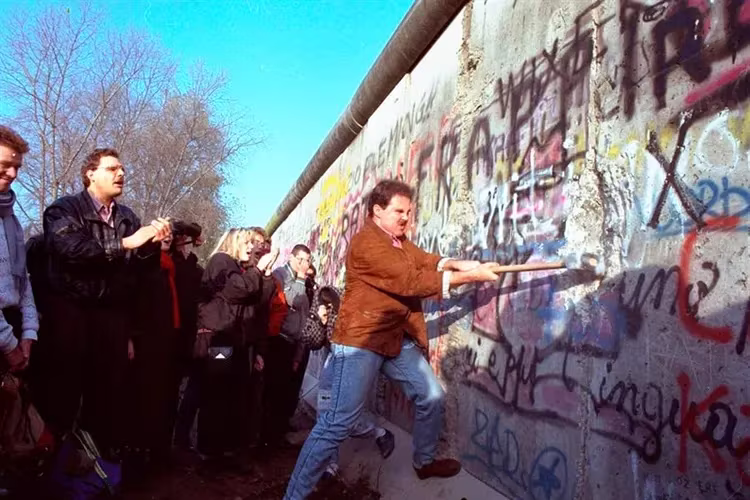
Berliners watching the performance on TV were dumbfounded. When the first shock passed, people from both sides of the border rushed to the hated fence. The border guards did not hold back their pressure. The reunion, which was dreamed of for 28 years, took place. The demolition of the Berlin Wall began on June 13, 1990 at Bernauerstrasse. But even before that moment, the townspeople broke many of its fragments, taking pieces of concrete as a souvenir.
Interesting Facts
For those of you who want to include a visit to the infamous landmark in the excursion program, it will be interesting to know the information that guidebooks do not contain. So, the Berlin Wall: facts and figures.
-
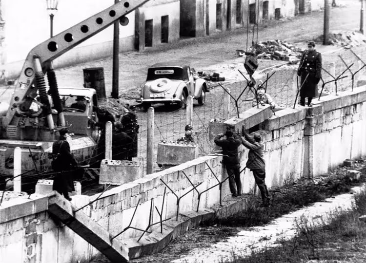
On October 27, 1961, a confrontation between American and Soviet troops took place at the checkpoint on Friedrichstrasse – 30 battle tanks collided at the border.
-
On June 11, 1964, French President Charles de Gaulle informed the USSR ambassador about the possibility of starting a nuclear war in the event of a new military conflict in Berlin.
-
Despite enhanced security measures, between 1961-1989. 5,000 citizens managed to get over the fence. Taking advantage of their official position, 1,300 GDR soldiers also crossed the border.
-
After the opening of the passage, West Berliners showed generosity to the East German border guards – bars near the wall dispensed free beer.
-
Today, some of the segments of the concrete monster can be found in different parts of the world, such as the CIA headquarters and the Vatican.
-
The construction and protection of the border fence became a great economic burden for the GDR. The cost was more than 400 million marks (200 million euros). Ironically, the “anti-capitalist stronghold” led to the collapse of the socialist country.
-
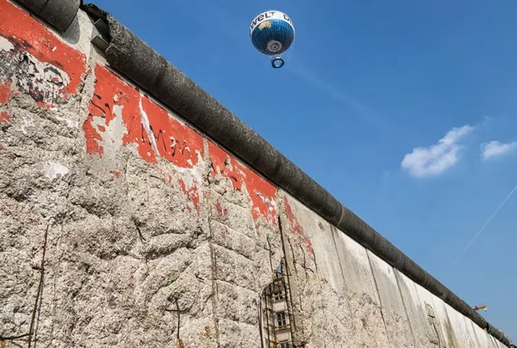
On November 9, 2014, on the day of the 25th anniversary of the fall of the Berlin Wall, 7,000 rubber luminous balls were installed along the entire perimeter of the former border, which soared into the sky at exactly 19:00.
Berlin Wall today
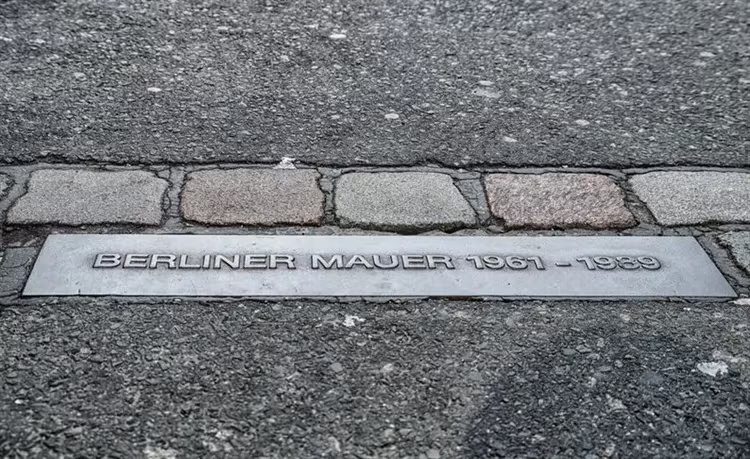
At present, only small fragments and a double line of paving stones, winding around the city like a long snake, remain from the building, which caused hatred and fear in people for 28 years. In order for the memory of the victims to remain forever in the hearts of people, the Berlin authorities opened several museums and memorial centers located next to the remains of the wall.
Memorial on Bernauerstrasse
“Window of Memory” – this is the name of the memorial, created to familiarize contemporaries with the tragic events associated with the split of the capital. It is dedicated to people living in the eastern part and trying to get into the western part by jumping from the windows of houses and breaking to death. The monument is a rusty iron composition containing photographs of the dead.
Nearby there is a zone of gray concrete and a border strip, a tower, a Chapel of Peace built on the site of a blown up Gothic temple, a library, a museum and an observation deck. You can get to the memorial by metro (line U8). Stop Bernauerstrasse.
Topography of terror
This place is reminiscent of the countless tragedies caused by the Nazi regime. The museum is located on the territory of the headquarters of one of the leaders of the SS – Reichsführer Himmler. Now in the pavilion with an area of 800 m2, visitors can look at photographs and documents introducing the genocide and other crimes of fascism. Nearby, in the open air, are the ruins left over from the barracks and cellars of the Gestapo, and part of the Berlin Wall.
Address: Niederkirchnerstrasse 8. You can get here by S-Bahn (city train). Line U2 to Anhalter Bahnhof.
Checkpoint Charlie
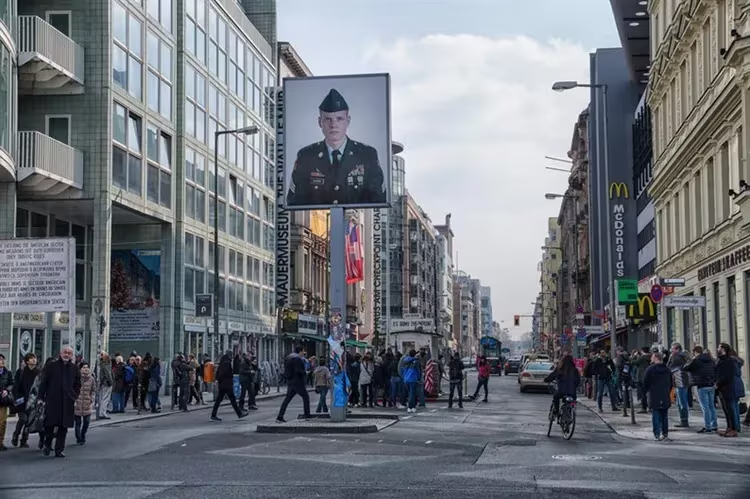
At the former border checkpoint for diplomats and officials, where in 1961 there was a conflict – the confrontation between Soviet and American tank divisions, today there is a museum of the Berlin Wall. Among the exhibits are unique photographs and devices with which the East Germans moved to the western side: scuba gear, hang gliders and balloons. Near the museum there is a model of a sentry box with “soldiers” standing nearby, dressed in American military uniforms of that time. “Border guards” willingly take pictures with everyone.
Checkpoint Charlie is located on Friedrichstrasse next to Kochstrasse metro station. The museum is open every day from 9:00 to 22:00.
East Side Gallery
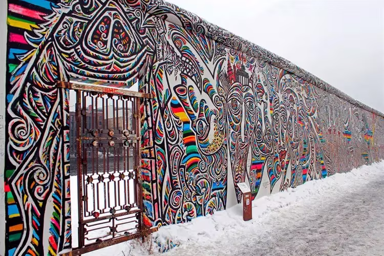
In the eastern part of the metropolis there is a piece of the wall, which is 1,300 m. In the spring of 1990, 118 artists from 21 countries began to paint the concrete canvas. The result is the East Side Gallery, the longest open-air exhibition in the world. One of the famous works is a drawing by the Soviet artist Dmitry Vrubel depicting a passionate kiss between the leaders of two socialist states – Eric Honecker and Leonid Brezhnev.
But most of the authors who adorned the stone canvas are ordinary people who demonstrated their attitude to the dark pages of Berlin's history. Over the years, many images of the gallery have suffered from rain and wind. In 2000, 40 graffiti were restored, and after another 8 years, a global reconstruction took place, the cost of which was 2.2 million euros.
East Side Gallery stretches along Muehlenstrasse. You can get to it by train (S-Bahn) lines S5, S7, S75 to Ostbahnhof or Warschauer Strasse stations.
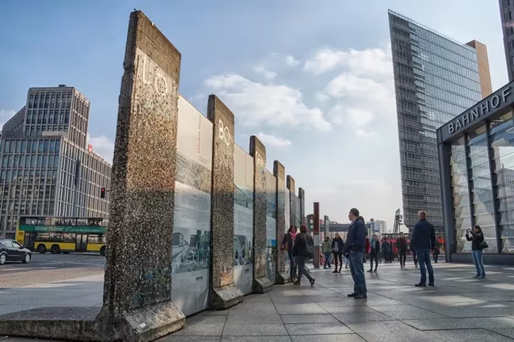
Small sections of the Berlin Wall are located in the very center of the city – on Potsdamer Platz, completely destroyed during World War II and rebuilt at the end of the last century.