
Canyonlands National Park in USA – photo, description, map
Tourists from all over the world come here to see the unique geological deposits, as well as get closer to the history of human development and ancient evidence of prehistoric Indian culture. This corner of untouched nature is located in the south of Utah within the Colorado Plateau. We are talking about Canyonlands National Park, located at an absolute height of 1.4 to 2.8 thousand meters. This rocky area cut by precipitous river canyons lies within a desert area that never receives more than 250 mm of precipitation per year. In winter, the temperature here can drop to -8 degrees, and in summer it exceeds +24. The daily temperature range here is about 50 degrees. In these extreme climatic conditions, peculiar landforms were formed, and thousands of years ago people lived here.
History of the park
Scientists managed to establish that the first people who appeared here from 2 thousand to 10 thousand years ago were hunter-gatherers. Later, from the search for edible plants and hunting for game, the ancient inhabitants of these places switched to agriculture and began to engage in handicrafts, making vine products and developing pottery. The ancient Indians already lived here in large settlements 450 years before our era and used special underground structures called “kiva” to perform certain rituals. In the XIII century, for some reason, they left this area.
Mastering the Wild West and penetrating deep into the territory already in the 18th century, the Americans accidentally stumbled upon this territory. However, not the beauty of the surrounding nature, but quite practical ideas attracted a lot of lovers of easy money here. In the gorges of the canyon, criminals and smugglers hid from justice. During the years of the “uranium rush,” miners made their way here, trying to make a fortune on radioactive gold. All this subsequently contributed to further research and study of this territory.
Seriously, the archaeological heritage and recreational resources of this part of the Colorado basin were taken up in the 50s of the last century. And in 1964, the American President signed into law the creation of the Canyonlands National Park.
Surreal landforms
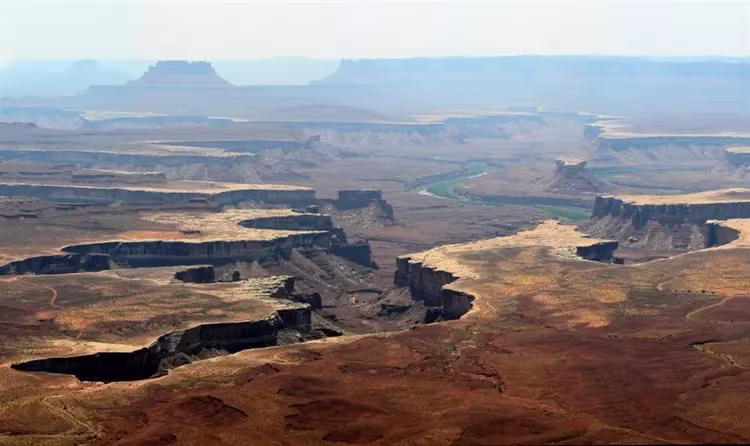
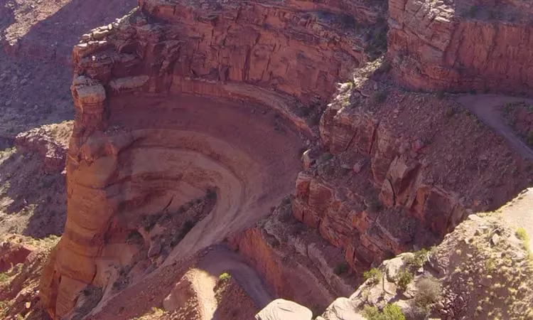
On the example of the classical relief of Canyonlands, one can visually study the geological processes that took place on Earth. The Colorado Plateau, within which the National Park is located, is part of the continental crust. In the process of formation, sediments accumulated on its surface, formed as a result of weathering and periodic advances of the ocean to the mainland. The remaining oceanic sediments thickly covered the layers of sedimentary rock below. Under their pressure, metamorphization processes took place, during which the underlying rocks acquired hardness.
Due to vertical tectonic movements, the western part of North America slowly rose, forming the Colorado Plateau. At the same time, the Colorado and Green channels, cutting into the rock mass, formed deep canyons. On the territory of Canyonlands, their depth is about 600 meters. As a result of internal processes, intense weathering and desert climate conditions, not only picturesque canyons, but also other completely surreal landforms were formed on the plateau.
From Island in the Sky to Labyrinth
The territory of the park occupies such a huge area that it is divided into separate parts. Each of them has its own name. In parts of the park, called the Island in the Sky and the Needles, it is possible to travel by car, and the Labyrinth and Horseshoe Canyon move exclusively on foot.
island in the sky
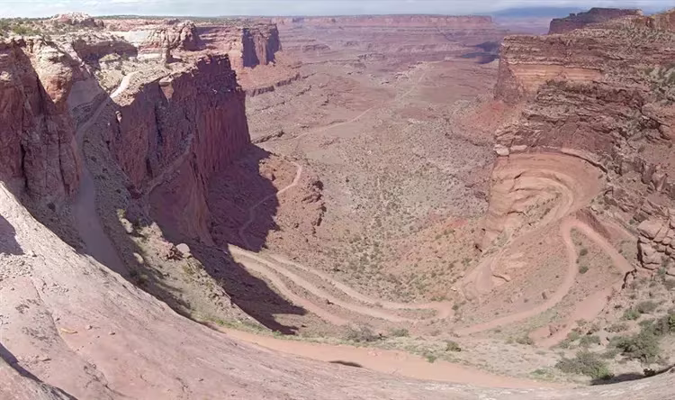
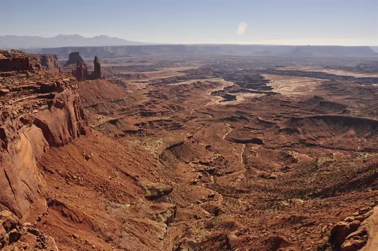
The island in the sky is located on the Green and Colorado watershed and lives up to its name. Its absolute height is more than 1.8 thousand meters. From here you have a wide view of the territory of the entire National Park. Among the picturesque landscapes and bizarre landforms, a crater formed 170 million years ago with a diameter of about 5 km deserves special attention. Despite its high altitude, Island in the Sky is the most visited and most accessible part of Canyonlands for most tourists.
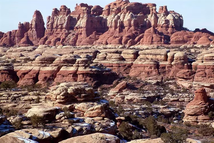
Needles
Of great interest to tourists is visiting Eagles. This name was given to the territory due to the accumulation of bizarre rocks formed as a result of erosion processes. Numerous canyons, aerial arches and mysterious caves, over which rise red and white sandstone spiers, give the Eagle landscape a fantastic look. You can move around the territory of the Eagle not only by car, but also on foot or by bicycle. Fans of outdoor activities often visit Needles. Among the most popular attractions here are Angel Arch, Elephant Mountain and Indian Creek cliffs. The steep cliffs of Indian Creek attract climbers from all over the world, where everyone is trying to try their abilities and skills.
Horseshoe Canyon and Labyrinths
Horseshoe Canyon attracts lovers of antiquity. It was here that the rock paintings of the Indians of North America were discovered. In addition to signs and symbols, here you can see images of human figures. The rock paintings occupy the gallery, which is four and a half meters high and 61 meters wide.
The most remote and most inviting place in the Canyonlands is the territory of the Labyrinths, which consists of a group of canyons. It is impossible to get here by any transport. This remote place can be reached by moving exclusively on foot. Even if you manage to overcome the difficult path to the Labyrinths, do not relax. Traveling through the labyrinths of the canyons is much more difficult. Therefore, not everyone can visit this part of the park. All those who volunteered to visit the Labyrinth must demonstrate excellent physical data and fully provide themselves with food and drinking water. Those tourists who want to test themselves, to be in silence and loneliness prefer to go on this fascinating journey.
Entertainment
The varied terrain in this national park favors a variety of recreational activities. Therefore, here you can meet fans of mountaineering, and lovers of hiking, and cyclists. On the calm sections of the Colorado and Green, you can go canoeing, and in places with a rough current, you can go rafting and kayaking, overcoming the rapids. In Canyonlands, you can simply relax while admiring the changing illumination of the rocks during sunrise and sunset.
It is worth noting that in this area everything is done to ensure that tourists fully experience the charms of primeval wildlife. Therefore, unlike other similar parks in Canyonlands, there is no running water, only dirt roads are laid, and hikers can move along primitive paths.
Recommended reading Mesa Verde in the USA.