
















Jacob's Well in Texas: why swimming is closed and how to see it from the shore
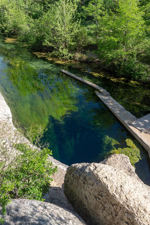
Jacob's Well looks like a bottomless window into the earth. From above, you can see the water disappear into the limestone and vanish into the darkness.
Swimming here is no longer allowed. Since June 2022, the spring has not been flowing the way it used to, so the county closed access to the water until the flow recovers (as of 09/2026, park page on the county website). You can still see the well itself, and entry to the natural area remains free.
Below, read about why the spring is drying up, what makes it dangerous, and how to get here from Austin.
Ad: this article contains affiliate links, we earn a commission if you book through them, at no extra cost to you.
What Jacob's Well is
💡 In short:
- The natural area is open daily from 8:00 AM to 6:00 PM, last entry at 5:30 PM (hours, 09/2026).
- Entry is free, no reservation is needed for a walk, and swimming has been closed since June 2022 (status).
- It's about 400 meters from the parking lot to the overlook at the well, part of the way over rock and stairs (county data).
- Prices, hours, and swimming status: 09/2026, verified on the official Hays County website
 © Larry D. Moore · CC BYPhoto: Larry D. Moore, CC BY (https://creativecommons.org/licenses/by/4.0), Wikimedia Commons
Jacob's Well is a karst spring in the bed of Cypress Creek, northwest of Wimberley. The round opening, about 3.7 meters wide, serves as the entrance to an underground system (spring description). The water rises from the Trinity Aquifer, so it stays cold even on a hot day.
The landmark for your GPS is simple: 1699 Mt. Sharp Road, Wimberley, TX 78676 (address and map, 09/2026).
The well was named after the biblical Jacob's Well in Nablus on the West Bank, which was carved into the rock by hand. In Texas, the water itself created the fissure. That's the main oddity of this place: a quiet creek on the surface, and an abyss below.
History and geology of the spring
The spring has been flowing out of the limestone for thousands of years, gradually carving a vertical shaft into the rock. In 1924, the flow was measured at about 640 liters per second, and the jet rose about 1.8 meters above the creek bed (measurement history). Over time, pumps operated by the water utility began drawing water from the Trinity Aquifer faster than it recharges.
For the first time in recorded history, the spring stopped flowing in 2000. The same happened in 2008, 2011, 2013, and 2022 (chronicle of dry spells). In 2010, the county bought 50 acres of land around the well to protect the site from development. Together with adjacent parcels, that created about 81 acres of natural area (as of 09/2026, area and status).
Simply put, you are traveling to a vanishing landmark. Its condition depends on rainfall and on water extraction from the aquifer.
Underwater caves: why diving is banned here
The opening drops almost vertically for about 9 meters, then the passage tilts and turns into a chain of chambers with narrow restrictions (cave structure).
The upper chamber still has enough light, and fish and aquatic plants can be seen here. Below begins the dark section. Without specialized equipment and training, turning around in a restriction is impossible, and that is exactly how people have died here.
Divers from the Jacob's Well Exploration Project mapped two main passages. The main one extends 1,400 meters from the surface, with a maximum depth of 42 meters. The second branches off to the side and runs about 300 meters (map of passages).
The average depth of the cave is about 37 meters. The chamber floors are covered in calcareous silt: a sudden movement stirs up the sediment, and visibility disappears within seconds (description of the floor). In that kind of murk, you will not find the exit without a pre-laid guideline.
From 1964 to 1984, nine people died in the well (dive statistics). After that, the county banned SCUBA diving here, and the ban remains in effect to this day (as of 09/2026, park rules). Beginners and cliff-jumping enthusiasts have no business at the well: access to the water is closed.
Myths and legends about the well
The local legend is short: jump into the well once, get dressed quickly, leave, and never come back, and you will be lucky. There is no way to test this anymore, because swimming is closed (swimming status). But the legend does explain why the place drew people in so strongly: divers kept coming back again and again, until the county banned diving.
Where Jacob's Well is located
The well lies within the Jacob's Well Natural Area. This is 81 acres of land near Wimberley, Texas, Hays County (as of 09/2026, county). Cypress Creek below the well flows through Blue Hole Regional Park and empties into the Blanco River (creek hydrology).
 © Aleksomber · CC BY-SAPhoto: Aleksomber, CC BY-SA (https://creativecommons.org/licenses/by-sa/4.0), Wikimedia Commons
For you, this means the well sits away from the major tourist routes. For lodging and shopping, it is more convenient to drive to Austin, the capital of Texas. There is no public transportation in Wimberley, so plan on having your own car or arranging a transfer.
How to get to the Well from Austin
From Austin to Wimberley is about 60 kilometers, roughly a 45-minute drive (on the map). Austin-Bergstrom Airport is southeast of downtown, and it is easiest to pick up a car right at the terminal.
Book your car in advance: in summer, rental fleets sell out quickly. Compare car rental prices in the US a couple of weeks before your trip.
 © Travis K. Witt · CC BY-SAPhoto: Travis K. Witt, CC BY-SA (https://creativecommons.org/licenses/by-sa/4.0), Wikimedia Commons
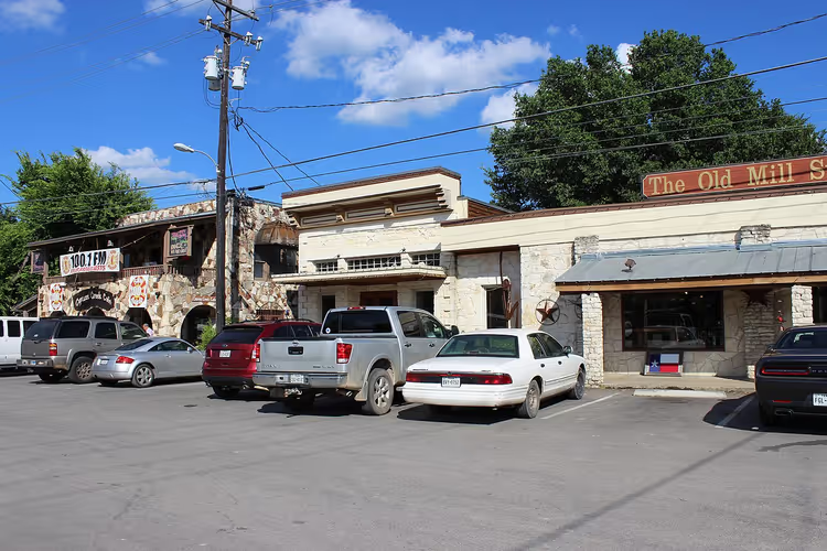
From Wimberley to the entrance of the natural area is about 5 kilometers, or a 10-minute drive (on the map).
The parking lot at the entrance is small, and on weekends spaces are gone by morning (as of 09/2026, parking and tips). Separate spaces are set aside for RVs and trailers, but if you plan to visit with a trailer, it is better to call ahead at (512) 214-4593 (parking questions).
Hours, admission, and rules
Everything important to know before your trip is in the table below.
Item | What applies |
|---|---|
Hours | daily 8:00-18:00, last entry no later than 17:30 |
Admission | free, no reservation needed for a walk |
Swimming | closed since June 2022 |
Diving | SCUBA is prohibited |
Closed days | April 5, November 26, December 25, 2026, and January 1, 2027 |
Pets | not allowed on trails or in the parking lot |
Phone | (512) 214-4593 |
Table data as of 09/2026, Hays County data.
The rules are short, but if you break them, you will be escorted off the property. Glass containers, alcohol, and grills are not allowed, nor is smoking, pitching tents, riding bicycles, or flying drones (list of rules).
Bring food and water with you: the park sells neither food nor souvenirs, and the water fountain is at the Nature Center near parking lot C (visitor questions). The descent to the well goes over rock and stairs, so wear non-slip shoes.
When to go

Summer in Texas is hot: in June through August, temperatures reach 35-38 °C (according to county data, 09/2026, summer temperatures). The water in the well stays cold, but swimming is not allowed, so the heat works against you. Arrive at opening time, 8:00, and bring at least a liter of water per person.
Spring and fall are the mildest seasons here: temperatures are comfortable and mosquitoes are fewer. In winter, days are cool, but snow and freezing temperatures are rare, so the trails stay open year-round.
If swimming is your main priority, check the status before you go. The well was usually open for swimming from May 1 to September 30, and only by online reservation (swimming rules). Reservations are not currently open, and water flow data is published by USGS.
What to see nearby
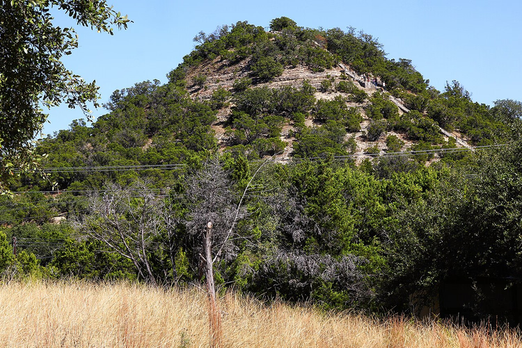
The natural area is small, but it is easy to keep yourself busy here. The park has about 3 miles of trails, and the main trail to the well is 400 meters and a 15-minute walk (park trails). Part of the route runs over granite gravel, part over limestone, and there are two or three staircases along the way.
Besides the well, the park has a geocaching area, picnic spots, a playground, a labyrinth, a sundial, and a garden with interpretive signs. Birdwatching is also on the park's list of activities (park activities).
On Saturdays from September through June, the county offers free guided tours. They start in the morning and last about an hour, no registration required (tours).
Nearby are Blue Hole Regional Park and Karst Canyon Preserve, and Austin is a 45-minute drive away (on the map). Austin tours on GetYourGuide are useful if you want to add an urban program to your nature outing.
Tours and tickets in Austin
Guided tours, skip-the-line tickets and activities — most offers can be cancelled free of charge.
See offers on GetYourGuideThe widget loads once you give your consent.
Jacob's Well on the map
The well is northwest of Wimberley, off Mt. Sharp Road. Parking is before the entrance, and from there you walk along the trail.
⁉️🤔 Frequently asked questions
Can you swim at Jacob's Well right now?
No. Swimming remains closed until the water flow returns to normal (as of 09/2026, Hays County). When water levels are low, swimming degrades water quality and harms neighbors downstream. The county announces the season opening separately.
How much does entry cost and do you need a reservation?
Entry is free, and no reservation is needed for walking (hours and entry). Reservations used to be required for swimming, but there is currently nowhere to sign up.
How do you get to the well without a car?
There is no public transportation to Wimberley, and taxis here are rare and expensive. Rent a car at the Austin airport or in the city (car rental). From Wimberley to the park entrance is about 5 kilometers (on the map), followed by a short trail to the well.
Can you come with a dog and a stroller?
Dogs are not allowed: animals are prohibited on the trails, in the parking lot, and near the water (rules). A stroller is also inconvenient, since the descent to the well goes over rock and stairs. There is a playground, a labyrinth, and picnic areas for children. If someone has difficulty walking, call ahead: staff can drive visitors to the well (accessibility).
How much time do you need for a visit?
Plan for an hour and a half to two hours. The walk to the well takes about 15 minutes each way (route to the well), and the rest of the time goes to the overlook, photos, and the walk back. In hot weather, allow extra time and bring water.
When will the spring flow again?
Nobody can say for sure. The condition of the well depends on rainfall and on how much water is being drawn from the aquifer (spring hydrology). Before 2000, the spring never ran dry, but since then it has happened several times. Water flow data is updated by the USGS.
In short: what is worth booking
If you are coming from Austin for one day, get a car and leave in time for opening. If swimming is your main priority, plan your trip around another body of water and check the well status on the county website before you go. If you are traveling with children, plan the walk for the morning and bring water.
What to book in advance: a car. Find and book a car in the US before your trip.
Look for lodging in Austin or Wimberley: you cannot stay overnight in the natural area itself. You will see the well from the shore.

A small editorial team writing guides for independent travel. We travel ourselves, but we haven’t been everywhere, so we check prices, opening hours and how to get there against official sources.