
















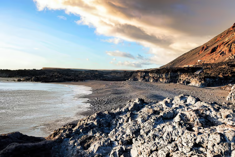
La Palma: hikes to volcanoes, the crater and laurel forests
La Palma looks like an island made for hiking. In the center lies the huge Caldera de Taburiente crater, and along the entire south runs the Cumbre Vieja ridge with black lava fields. There are no big hotels or noisy resorts here. Instead, there are marked trails, mountain villages, and mild weather almost any month of the year.
Planning a trip is easier than it seems. In short, for orientation: in four to five days you can hike Ruta de los Volcanes, descend into the crater from Mirador de Los Brecitos, and climb to the island's highest point, Roque de los Muchachos. Between hikes, there's still time for the salt flats, black sand, and fish in the port of Tazacorte.
Ad: this article contains affiliate links, we earn a commission if you book through them, at no extra cost to you.
An island of volcanoes and laurel forests
La Palma closes out the western group of the Canary Islands and lies about 1,500 km from mainland Spain. The elevation starts almost at the shore: the terrain is defined by the Caldera de Taburiente crater in the center and the Cumbre Vieja volcanic chain in the south. There are few roads, so you can drive the island from end to end in a couple of hours.
The climate is steady year-round. The Canary Current and the trade winds keep temperatures from going to extremes, but weather varies significantly within the island. The south is almost always sunny. The northeast is more often under clouds that cling to the mountains and release rain. At around 2,000 m elevation it's noticeably colder and windier, so you pack a shell jacket even in summer.
A separate chapter of the island's history is tied to the Tajogaite volcano. The eruption on Cumbre Vieja began in the fall of 2021 and lasted several months: lava flows reached the sea and reshaped the southwestern coast. Today it's one of the youngest lava areas in Europe. The island is suitable for hiking year-round, but in summer the lowlands are hot, while in winter it's comfortable by the sea.
💡 In short:
- For a first trip, go for the south and the center: Ruta de los Volcanes, the Caldera de Taburiente crater, and the Roque de los Muchachos ridge.
- Shoes with an aggressive tread and trekking poles are essential: descents on the island are longer and steeper than the ascents.
- Trail access and conditions: 09/2026, according to the official La Palma trails portal.
The main hiking routes of La Palma
The island has hundreds of kilometers of marked trails, but the core consists of the six routes below. Almost all of them start at designated parking areas or bus stops, so you don't need a car for every outing. See the table for distances and elevation gain.
Route | Length | Elevation gain | Time | Difficulty |
|---|---|---|---|---|
Ruta de los Volcanes | 18.1 km | 1498 m | about 6.5 h | high |
Teneguía volcano and salt works | 13 km | 750 m | 5 h | medium |
Caldera de Taburiente | 13 km | 1200 m descent | 5-6 h | medium |
Barranco de la Galga | 7 km | about 400 m | 3 h | low |
Roque de los Muchachos | 11.5 km | about 600 m | 4.5 h | medium |
Los Tilos | 16 km | 1100 m | 6 h | medium |
Route data: 09/2026, data from the official trails portal.
Important: many routes on La Palma run predominantly downhill. The trails are marked, but often steeper than in the Alps and require a confident stride. Always bring a rain jacket, and trekking poles make the descent noticeably easier.
Ruta de los Volcanes: crossing recent lava fields
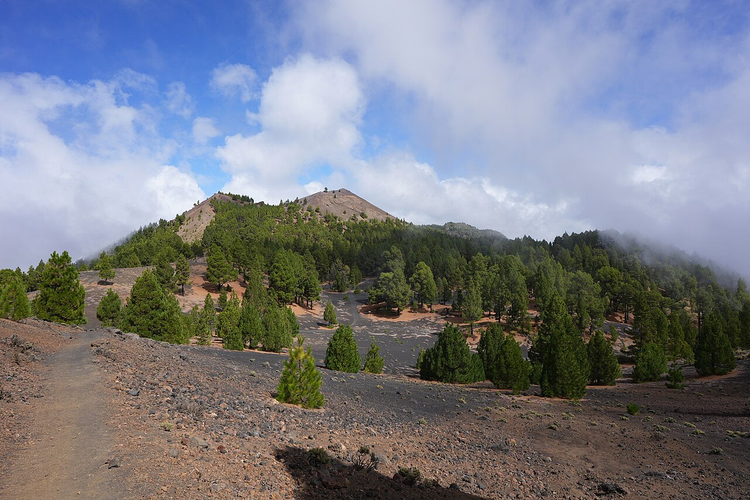
The island's most famous route follows the Cumbre Vieja ridge from Refugio del Pilar to the village of Los Canarios. The official trails portal lists 18.1 km, 1498 m of elevation gain, and about six and a half hours (official Ruta de los Volcanes specs, 09/2026). Along the way you pass young cones and lava fields, with Tenerife, La Gomera, and El Hierro on the horizon.
 © Ingo Mehling · CC BY-SAPhoto: Ingo Mehling, CC BY-SA (https://creativecommons.org/licenses/by-sa/4.0), Wikimedia Commons
The start is at the Refugio del Pilar area in El Paso. A taxi from El Paso, Los Llanos de Aridane, or San Isidro will drop you at the trailhead, which is the most convenient option. The finish is in Los Canarios, where a bus goes to Santa Cruz and Los Llanos: check the schedule on the TILP carrier website. Bring at least two liters of water; there is almost no shade on the ridge.
- Who it's for: you're ready for a long traverse and want to see several islands at once.
- Location: the Cumbre Vieja ridge in the south of the island, between El Paso and Fuencaliente.
- The catch: there is no drinking water or shelter on the route, and in the heat it becomes a serious test.
Teneguía volcano: down to the lighthouse and salt works
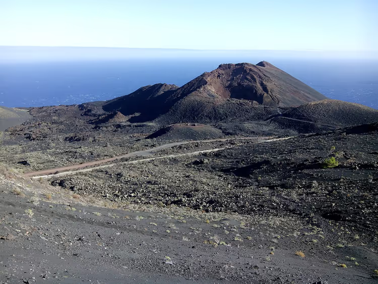
From Los Canarios, the GR 131 route leads down through black volcanic sand to the Teneguía volcano and its summit. From the top you get a panorama of Tenerife, La Gomera, and El Hierro. The trail then crosses cinder fields and reaches the sea at the Faro de Fuencaliente lighthouse, where the salt works are worth a visit. The trails portal lists 13 km, five hours, and 750 m of elevation gain (Teneguía route data, 09/2026).
 © Benjamín Núñez González · CC BY-SAPhoto: Benjamín Núñez González, CC BY-SA (https://creativecommons.org/licenses/by-sa/4.0), Wikimedia Commons
To get back to the village, you can walk up past the wind farm along the lava slopes. Another option: a bus runs from the lighthouse to Los Canarios. Allow an extra one to two hours for the visitor center at Volcán de San Antonio at the start and the salt works at the end.
- How to get there: bus from Santa Cruz to Fuencaliente, then continue on foot along the route.
- The catch: most of the route is exposed to the sun, so you need a hat in summer.
Caldera de Taburiente: descent from Mirador de Los Brecitos
Caldera de Taburiente National Park occupies the center of the island, and its main route starts at the Mirador de Los Brecitos viewpoint. You can only get there by taxi: private cars are not allowed, and a shuttle taxi from the Barranco de las Angustias parking area costs a fixed amount per car, which passengers split among themselves. Confirm the exact price when you board.
The trail then descends through pine forest into a deep gorge with streams. The official length is about 13 km, with a time of five to six hours (Caldera de Taburiente specs, 09/2026). Along the way, it's worth making an hour-long detour to the Cascada de los Colores waterfall. Lower down you pass the Roque Idafe rock and emerge into Barranco de las Angustias along the riverbed. There are toilets and water at the visitor center at the bottom.
 © H. Zell · CC BY-SAPhoto: H. Zell, CC BY-SA (https://creativecommons.org/licenses/by-sa/3.0), Wikimedia Commons
- Who it's for: you want to see the park from the inside, not just from a viewpoint.
- The catch: the route runs almost entirely downhill, putting serious strain on your knees; poles here are not a luxury.
Barranco de la Galga: the island's greenest route
This route lies in the northeast of the island and follows the bottom of the Barranco de la Galga gorge through dense laurel forest. You walk along old water channels, the canopy closes overhead, and light filters through the leaves in patches. The route portal lists about 7 km and three hours of walking (Barranco de la Galga data, 09/2026). The start is at the parking lot on the LP-1 road next to the info hut.
 © Frank Vincentz · CC BY-SAPhoto: Frank Vincentz, CC BY-SA (https://creativecommons.org/licenses/by-sa/3.0), Wikimedia Commons
In summer this is the best option for a hot day: it's cool and humid under the forest canopy. The catch is something else: after rain the rocks get slippery. Bring poles and don't count on wide viewpoints, there are almost none here.
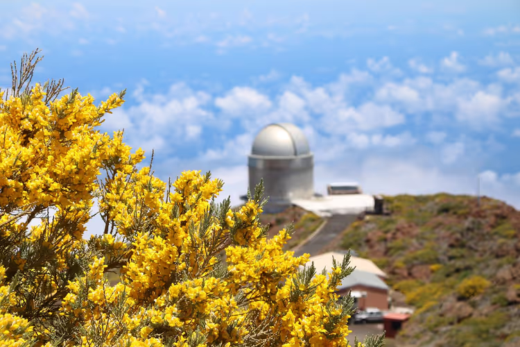
Roque de los Muchachos: along the crater rim
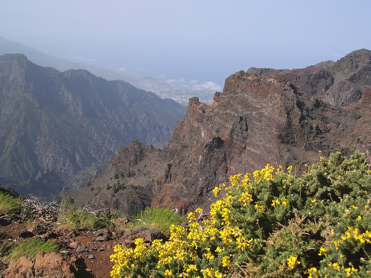
This high-altitude route follows the crater rim and takes in the island's main peaks. It starts at the parking lot near Pico de las Nieves and finishes not far from the observatory on Roque de los Muchachos. The route portal gives 11.5 km and about four and a half hours of walking (Roque de los Muchachos specs, 09/2026). Elevation gain is about 600 m, but the trail stays above 2000 m almost the entire time, so bring a windbreaker.
 © I, Luc Viatour · CC BY-SAPhoto: I, Luc Viatour, CC BY-SA (http://creativecommons.org/licenses/by-sa/3.0/), Wikimedia Commons
The observatory sits right on the edge of the caldera, and from there you get a panorama of the entire crater. At sunset people come up here to stargaze: the sky over La Palma is considered one of the clearest in Europe.
Los Tilos: laurel forest, channels and tunnels
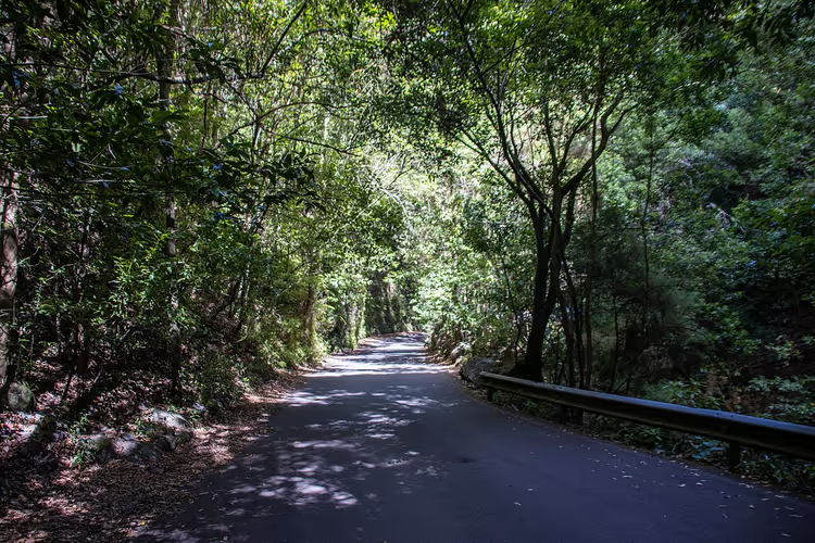
The route starts in Los Tilos and heads into the Barranco del Agua gorge. After 45 minutes of climbing, pines start mixing with laurel forest, and at about 1450 m the Cordero spring feeds into a channel. From there you walk along the channel and through a tunnel to the Marcos spring. The descent leads through a dozen tunnels up to 350 m long and ends at Casa del Monte on the road to Las Lomadas, where there's a bus stop.
 © Photograph by Mike Peel ( www.mikepeel.net ). · CC BY-SAPhoto: Photograph by Mike Peel ( www.mikepeel.net )., CC BY-SA (https://creativecommons.org/licenses/by-sa/4.0), Wikimedia Commons
Length is about 16 km, time six hours, elevation gain 1100 m (Los Tilos data, 09/2026). A headlamp and rain jacket are mandatory: the tunnels are dark and damp.
If you don't want to go on your own, the island has group hikes with local guides: La Palma tours on GetYourGuide put together small groups and handle the logistics. That solves the question of getting to the trailhead.
Beaches and coves between hikes
Swimming on La Palma requires attention: the west coast is usually calmer, while the east can have strong currents. Three spots are worth fitting in between hikes.
Playa Nogales lies beneath a green cliff near Puntallana in the northeast. It's black volcanic sand, with a staircase leading down to the water. Currents here are strong, so you can only swim close to shore and on a calm day. Nearby there's a detour to the Cueva del Infierno cave. You drive from Santa Cruz to the center of Puntallana, then follow the signs.
Playa de Candelaria hides in a cove under a rock overhang. From the village of Tijarafe you descend into the Barranco del Jurado gorge, at the bottom you reach the rocky Playa del Jurado, then a short climb and another descent into the cove. Under the overhang sits a tiny village of white stone houses: smugglers used to hide in them, today they're weekend cottages. The way back passes cave dwellings and follows the rocky coastline. Allow half a day for the whole walk.
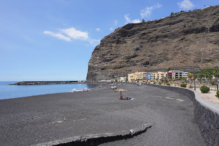
Playa Tazacorte near Los Llanos de Aridane is convenient for regular swimming: sand, cafes on the promenade, and the drive from hotels takes about fifteen minutes.
 © imehling · CC BY-SAPhoto: imehling, CC BY-SA (https://creativecommons.org/licenses/by-sa/3.0), Wikimedia Commons
Salt flats and old Santa Cruz
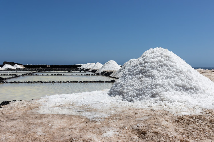
The Salinas de Fuencaliente salt flats have been operating for more than half a century. Seawater is evaporated in basins under the sun and salt is harvested several times a year, and the white terraces near the lighthouse are visible from far away. A visit takes less than an hour and pairs well with the route to the Teneguía volcano. Check opening hours and admission on site.
 © Photograph by Mike Peel ( www.mikepeel.net ). · CC BY-SAPhoto: Photograph by Mike Peel ( www.mikepeel.net )., CC BY-SA (https://creativecommons.org/licenses/by-sa/4.0), Wikimedia Commons
Santa Cruz de La Palma, the island's capital, was an important port in colonial times. You can see this on a walk through its cobbled streets: historic houses, squares, and churches stand side by side. In half a day you can cover the center on foot and return to the waterfront.
How to get to La Palma
You can fly to La Palma direct or with a connection from most major European cities. Flights are operated by Condor, Eurowings, and Lufthansa. The island has one airport, located in Santa Cruz de La Palma in the east, and from there you can reach Los Llanos or Los Cancajos in under an hour.
It's convenient to book an airport transfer in advance, especially for evening arrivals: public transport in the mountains runs infrequently, and taxis on site are not always available.
Tours and tickets in Santa Cruz de la Palma
Guided tours, skip-the-line tickets and activities — most offers can be cancelled free of charge.
See offers on KiwitaxiThe widget loads once you give your consent.
How to get around the island
The most flexible option is renting a car: you drive yourself to the trailhead and don't have to work around a schedule. Compare car rental prices in advance, as availability is noticeably thinner in July and August. Roads in the mountains are narrow and winding, so choose a more compact model.
The island's public transport is called guagua. The TILP bus network connects Santa Cruz, the airport, Los Llanos, Fuencaliente, and other villages. The fare depends on distance, and trips are cheaper with a Bono card (TILP operator). Check schedules in advance: mountain routes have few departures, and even fewer on Sundays.
Ready-made routes for the island are available in Komoot and Outdooractive, and for a paper option, the folding La Palma map from Freytag & Berndt works well. The catch with renting is different: parking lots at popular trailheads fill up by morning, so leave early.
Where to stay on La Palma
The list below is based on location: some options are convenient for the crater, others for the beach. Check prices on hotel websites, as they vary by season.
Hotel Benahoare in Los Llanos de Aridane is considered a good base for trips to Caldera de Taburiente. Breakfast here is hearty, with local fruit: bananas, papaya, and avocado. A double room starts at around €70 per night, depending on the season (hotel website).
Hotel Valle Aridane sits on the edge of Los Llanos' old town, within walking distance of the square. The breakfast terrace offers views over the Aridane Valley and the mountains. Playa Tazacorte beach is about fifteen minutes away by car (hotel website).
Apartamentos La Caleta in Los Cancajos on the west coast suits those who want to swim every day: the apartments are right by the waterfront, with restaurants and a cove nearby. Rooms are spacious, some with sea views, and you can cook for yourself.
Turismo Rural Isla Bonita rents restored Canarian houses in different price categories and in different corners of the island. They are usually quiet, set back from the roads. A house for two starts at around €50 per night, depending on the season (website).
Through a tour operator: if you want to skip the logistics and travel with a group, Wikinger Reisen offers La Palma options, including classic guided hikes (operator website).
To see rooms for a specific date on one search page: La Palma hotel prices on Trip.com.
Where to eat on La Palma
The island's cuisine is simple and built on local products: fish, bananas, potatoes, and goat cheese. Below are places where these are prepared without unnecessary fuss.
El Duende del Fuego in Los Llanos de Aridane. The owner of this gastrobar focuses on local organic products, offers options for guests with allergies, and the presentation is reminiscent of Renaissance cuisine (bar website).
The port of Tazacorte is the best address for fish. Along the lively waterfront of Puerto de Tazacorte, restaurants stand side by side, and at Kiosco Teneguía you can order a fish platter for one or for a group.
Franchipani on the road from El Paso to Los Llanos blends Spanish and Mediterranean cuisine with influences from other regions (restaurant website).
Taller de Pasta in Los Llanos makes homemade pasta, and portions are generous. Book a table in advance, the dining room is small (website).
Franconia Fusion El Bunker sits in the center of Los Llanos under old laurel trees. They serve local tapas here, and the address is easy to find by the sign on Plaza de Espana.
Bar Parada in Los Canarios brings the whole village together. Order a Barraquito coffee and fresh almendrados almond cookies, baked right on the premises.
For planning, the La Palma guidebook from Michael Müller Verlag is useful: it combines tourist information with route descriptions. For current island news and the events calendar, check the island tourist office website.
⁉️🤔 Frequently asked questions
When is the best time to visit La Palma?
The island is suitable for hiking year-round. From July to September it's hot in the lowlands, so it's best to start early in the morning. From October to May the weather is milder, but at higher elevations there can be wind and rain. The south of the island is sunny more often than the northeast, which is worth considering when choosing your base.
Can you hike the Ruta de los Volcanes without a car?
Yes. You take a taxi to the start at Refugio del Pilar, and from Los Canarios you leave by bus.
Do you need a rental car on La Palma?
Not essential, but convenient. TILP buses connect the main villages, including the airport and Fuencaliente. If you set out at dawn or return late, a car saves time.
Is the Tajogaite volcano dangerous right now?
No. The eruption ended in late 2021, and today the volcano is open for viewing. Around Tajogaite there are free viewpoints you can reach by car without a reservation. Approaching the cone itself is only possible with a guide, which requires a separate tour.
What should you bring on the trail?
Water, a hat, sun protection, and a shell jacket. Trekking poles make descents noticeably easier, and a headlamp is needed on the route with tunnels near Los Tilos. Wear shoes with a firm tread.
In short: what to book
If you're visiting for the first time and want to see the highlights, base yourself in Los Llanos de Aridane and plan for five days. For daily swimming, Los Cancajos and Playa Tazacorte are better suited. Without a car, stick to Los Llanos and Santa Cruz, where buses depart for nearly all villages. For fans of long treks, we recommend starting with the Ruta de los Volcanes and adding Los Tilos.
Book your rental car in advance so you can reach trailheads at a convenient time: book a car on DiscoverCars.

A small editorial team writing guides for independent travel. We travel ourselves, but we haven’t been everywhere, so we check prices, opening hours and how to get there against official sources.