
















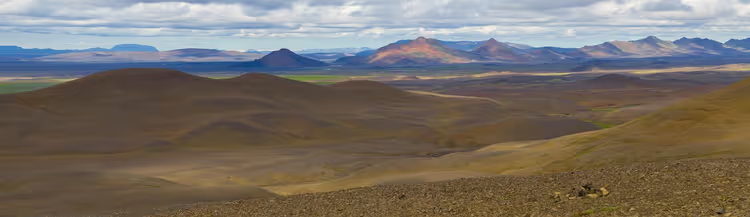
Shiprock in New Mexico: the sacred Navajo mountain where climbers are not allowed
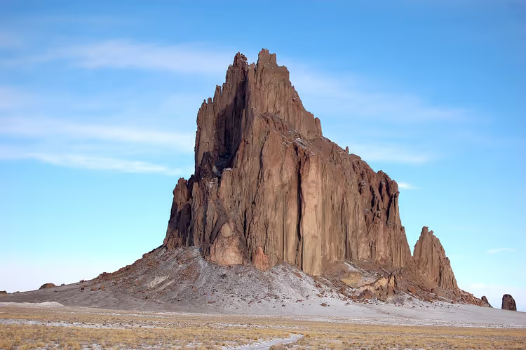
Shiprock rises above the Navajo desert in the state of New Mexico. You see it from the highway long before the turnoff. The lone rock stands in the middle of a flat plain, with no other mountain or landmark nearby.
You cannot climb it: the rock is sacred to the local people. Read on to learn what this place is, where the legends around it come from, and how to plan a trip.
Ad: this article contains affiliate links, we earn a commission if you book through them, at no extra cost to you.
What Shiprock is and where it stands
💡 In short:
- What it is: a volcanic "plug" in the middle of the Navajo desert in New Mexico.
- Height: the summit is at 2,188 m, with a 482 m rise above the plain (elevation figures, 09/2026).
- Climbing has been prohibited since 1970, no permits are issued (visiting rules, 09/2026).
- Convenient viewpoint: along US-491.
Shiprock stands in San Juan County, on Navajo Nation land, in the Four Corners region. The town of Shiprock, named after the rock, is about 17 km to the northeast (as of 09/2026, distance and coordinates). It is the most prominent landmark in northwestern New Mexico.
The name was not invented by the Navajo. Cartographers saw the silhouette of a 19th-century clipper hull, hence "Ship Rock." The upper spire was named "The Needle" in 1860 by Captain J. F. McComb, and the name was established on US Geological Survey maps in the 1870s (as of 09/2026, name history). The Navajo have their own name: Tse Bit'a'i, "rock with wings."
You see only the top of an ancient volcano. The base eroded away over millions of years, leaving above the plain the conduit through which magma once rose.
 © Bowie Snodgrass · CC BYPhoto: Bowie Snodgrass, CC BY (https://creativecommons.org/licenses/by/2.0), Wikimedia Commons
The road along the rock runs through open terrain, so plan your timing in advance. For an observer, distance matters less than the angle: from the north the silhouette resembles a ship, from the south it is just a rock wall.
Geology: why it is not a mountain but a volcanic plug
Geologists call such features volcanic necks. Shiprock is made of fractured volcanic breccia and black veins of minette, a variety of lamprophyre (as of 09/2026, rock composition). The magma solidified in the vent at a depth of 750-1,000 m below the surface, and the upper layers were later washed away by water and wind.
Dikes, stone walls of the same rock, radiate outward from the central massif. Radiometric dating of the minettes gives an age of about 27 million years (rock age, 09/2026). Shiprock is part of the Navajo volcanic field, where similar necks and flows formed roughly 30 million years ago. A similar neck stands in Monument Valley: Agathla (El Capitan) (field geology, 09/2026).
The difference between absolute elevation and rise explains why photographs deceive. A ground-level shot inflates the scale: you look up and lose your frame of reference.
Navajo legends of the winged rock
For the Navajo, Shiprock is not a tourist attraction but a place from myth. The name Tse Bit'a'i is tied to a legend about a great bird that carried the Navajo from the north to their current lands (as of 09/2026, legends and myths). After the flight, the people lived on the rock and climbed down only to tend their fields and fetch water.
One day, lightning struck the rock. The trail to the top collapsed, and the women and children remained on the summit. Since then, being on the rock has been forbidden: it is believed that a person would disturb the chindi, the spirits of the dead (as of 09/2026, text of the legend). This is how the myth explains what you see today: a sheer wall with no easy way up.
There is another story as well. Monster Birds (Tse Ninajaleeh) nested on the rock and fed on human flesh. The hero Monster Slayer killed two adult monsters and turned two chicks into an eagle and an owl (Navajo mythology, 09/2026).
In the myths, the rock also serves as a medicine bag or the bow of a mythical mountain figure. The body of this figure is made up of the Chuska Mountains, the head is Chuska Peak, the legs are the Carrizo Mountains, and the feet are Beautiful Mountain (as of 09/2026, geography of the myth).
Respect for the place is expressed in simple things. You do not climb the slope, you do not leave trash on the rocks, and you do not photograph local residents without permission. There are no ticket booths or a museum at the rock, and that is also part of its character.
Why climbing Shiprock is prohibited
The first documented ascent took place in 1939. A group from the Sierra Club, consisting of David Brower, Raffi Bedayn, Bestor Robinson, and John Dyer, completed a route that was later included in the list of classic climbs of North America (first ascent 1939, 09/2026). This climb was one of the first in the US to use expansion bolts for protection.
In total, at least seven routes have been climbed on the rock, and all of them are technically difficult. The easiest is considered to be a variation of that same line, but even it requires serious preparation. In the 1920s, the rock was called an unsolved problem of American climbing. At that time, there was also a rumor about a cash prize for the first ascent. No one ever paid the prize, but the rumor spurred dozens of attempts (climbing history, 09/2026).
In March 1970, three climbers suffered severe injuries. The Navajo Nation banned climbing not only on Shiprock but on all monoliths and spires within its territory. The wording was strict: the ban was declared "absolute, final, and unconditional" (Navajo regulations, 09/2026).
The Navajo parks service issues permits for camping and hiking routes in certain areas, but not for sacred monoliths like Shiprock. Climbers still come, and this is not a harmless adventure: at the base there is a memorial plaque honoring those who died on the routes.
In 1975, Shiprock was designated a National Natural Landmark. You do not need to climb to grasp the scale of the rock. It is enough to drive along it and look at the sheer wall from a safe distance.
How the view of the rock changes throughout the day
The color changes throughout the day, and with it the impression changes. At dawn in the haze, the rock appears silvery gray; by sunset it shifts to deep red and brown, and in winter the white snow on the plain emphasizes the blue-violet silhouette. In autumn, the monolith almost blends in with the brown sagebrush around it.
On an overcast day, the same rock looks grim. Gray skies, heavy clouds, and dark stone create a completely different mood, and you will easily understand where the local scary stories came from. From a bird's-eye view, the monolith looks like a small island amid the yellow expanses of the desert.
For photography, plan two visits: at sunrise and at sunset. At midday, the light becomes flat and shadows almost disappear. Stay on roads and designated viewpoints: you are on Navajo land, and the dirt roads here do not lead where your GPS says they do.
Highway 666 and its bad reputation
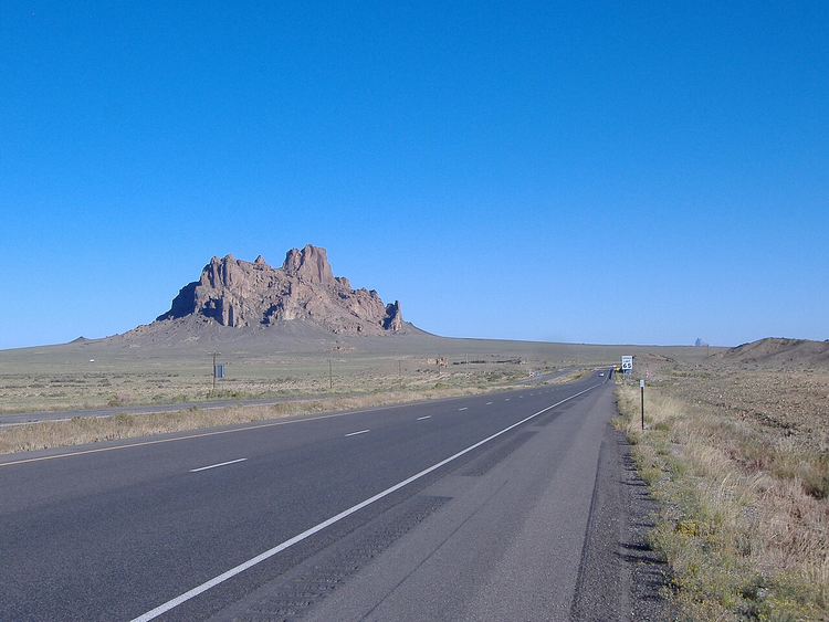
A highway with a difficult history runs past the rock. The old number, US 666, was replaced long ago: in 2003, the road was renamed US 491 (as of 09/2026, route history). The number 666 gave the road more notoriety than the road itself.
 © Peter K. · CC BY-SAPhoto: Peter K., CC BY-SA (https://creativecommons.org/licenses/by-sa/3.0), Wikimedia Commons
Road stories still include tales of frequent crashes, a phantom driver, and strange lights above the asphalt. Treat them as local folklore rather than fact. After the road was renumbered, the legends didn't disappear, but the route became popular with filmmakers: the cliff and the highway have appeared in films and been described in books (as of 09/2026, film and books).
Getting there and what to keep in mind
For your GPS, use the town of Shiprock on US-491 as a reference point; the rock is about 17 km from there (as of 09/2026, map location). You cannot do this without a car: distances in the desert are long and there are few services along the way. Fill up in town beforehand and bring extra water, even if you are only going for a couple of hours.
In summer, the heat on the plain makes long walks difficult; in winter, snow and ice on the road are possible. Plan your trip for morning or evening and do not count on stores near the rock.
 © Dicklyon · CC BY-SAPhoto: Dicklyon, CC BY-SA (https://creativecommons.org/licenses/by-sa/4.0), Wikimedia Commons
If you are coming from another city, compare car rental prices in New Mexico in advance. The most convenient places to stay overnight are Farmington, east of the rock, or the town of Shiprock, and the route through the Four Corners region is best planned as a single day.
⁉️🤔 Frequently asked questions
Can you climb Shiprock now?
No. Climbing Shiprock has been prohibited by Navajo law since 1970, and the ban applies to all monoliths on the nation's territory. Permits to climb are not issued even to experienced climbers. On the slope, you risk a fine, and for local people the mere presence of a person on the rock is offensive.
What does the name Tse Bit'a'i mean?
It is a Navajo name meaning "rock with wings." According to legend, a great bird carried the Navajo from the north to their current lands, and the rock served as a home for the people. The English name Shiprock came later: to mapmakers, the silhouette resembled the hull of a 19th-century clipper.
How much does it cost to visit the rock?
Shiprock has no tickets or ticket offices; there is no entrance fee. Your only expenses will be for travel and lodging: the rock stands away from towns, and you will cover the entire route by car. Camping and hiking routes in other areas of the nation require a permit.
When is the best time to visit the rock?
Morning and evening. In summer, daytime heat makes long walks difficult, and in winter snow on the road is possible.
Do you need a Navajo permit to drive to Shiprock?
No permit is needed to view it from the highway. The Navajo Parks and Recreation Department issues permits for camping and hiking in specific areas, but not for sacred monoliths like Shiprock. The nation's sacred sites are closed to any interaction, including climbing and filming on the slope.
In short: what to book
Shiprock requires no tickets or reservations, but it does require a car. If you have one day, pick up a car in the morning, arrive at the rock at sunset, and stay overnight in Farmington. If you are traveling through the Four Corners region, make Shiprock a separate point on your route: it sits on a direct road between the desert parks.
Before your trip, compare car rental prices in New Mexico and check the weather: in heat and snow, the drive to the rock turns into a long road with no stops.

A small editorial team writing guides for independent travel. We travel ourselves, but we haven’t been everywhere, so we check prices, opening hours and how to get there against official sources.