














What to see in Madagascar: a route from volcanoes to whales
Planning a trip to Madagascar is harder than just buying a ticket. The long flight, slow roads, and reserves several hours of rough driving from the capital put many people off. But in two weeks you can see lemurs, volcanic plateaus, a stone forest, and whales off the northern coast.
We've broken the island down into eight places worth including in your itinerary. Under each one you'll find how to get there and when to go. Apply for your visa online in advance (as of 09/2026, evisamada-mg.com). The dry season across most of the island runs roughly from April to November (as of 09/2026, Madagascar National Parks).
This guide is written for independent travelers. Below you'll find the details you need: visa, season, and transport.
Ad: this article contains affiliate links, we earn a commission if you book through them, at no extra cost to you.
Visa, season, and transport in Madagascar
💡 In short:
- Apply for your visa before departure, print the confirmation, and keep your return ticket handy.
- Go in the dry season: dirt roads are passable, parks are open, and the road to the stone forest is accessible.
- Cover long distances by plane, not two days in a car.
- Book domestic flights in advance.
- You'll definitely need cash in ariary.
- Visa, entry rules, and park entry: 09/2026, verified on evisamada.gov.mg and the national parks website.
Flights to Antananarivo are almost always connecting: you fly via Istanbul, Addis Ababa, Nairobi, or Paris. Ivato Airport itself is on the outskirts, and you can reach the center by taxi in about half an hour. Within the country, flying is often faster than driving: the island stretches from north to south, and the highways wind between hills.
The roads here are slow. Average highway speeds are low, and some routes run along dirt roads that get washed out in the rain. That's why logistics are built around the capital, or you hire a car with a driver for the whole route. A jeep with a driver costs more than renting on your own, but it eliminates the issues of night driving, repairs, and navigating unfamiliar terrain.
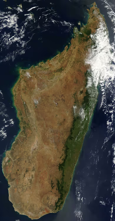
The climate also divides the island into parts. The west is arid because of winds from the Arabian side, the east is green and humid, the south resembles a desert, and the north is suited to beach holidays. We've picked one place from each part of the country so you don't get stuck only around the capital.
1. Zoma market in Analakely
There are few shops on the island; trade happens at markets. The main one, Zoma, takes over the blocks around Independence Avenue on Fridays. Locals buy everything here: dishes, fabrics, electronics, spices. Friday sets the rhythm for the entire city center. For travelers, the mineral stalls are more interesting, with beryl, agate, jasper, and tourmaline. Madagascar is considered the world's leading supplier of vanilla, so you can pick up spices right there at the neighboring stall.
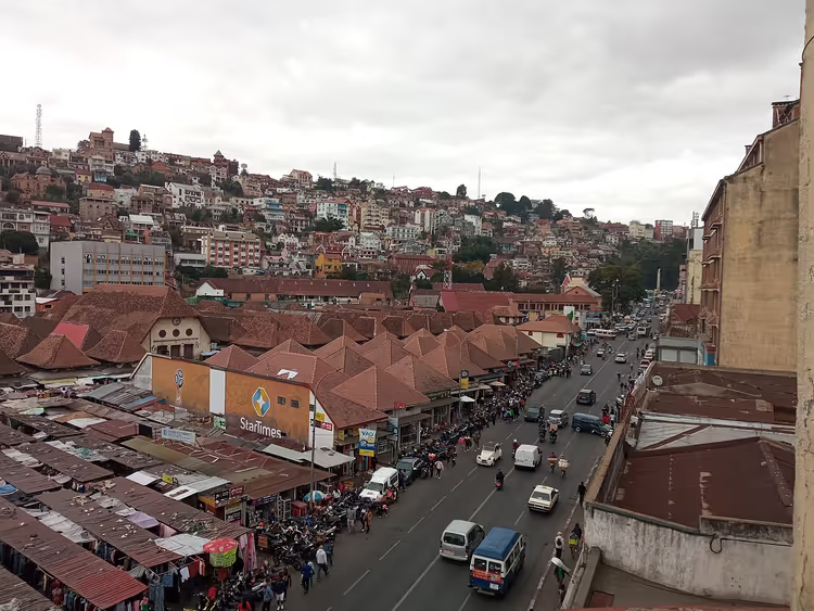 © Cactus0625 · CC BY-SAPhoto: Cactus0625, CC BY-SA (https://creativecommons.org/licenses/by-sa/4.0), Wikimedia Commons
- How to get there: Analakely center, on foot from Independence Avenue.
- Who it's for: those who want to see how the city trades, not just hotel shop windows.
- The catch: the market mostly comes together on Fridays; on other days the selection is noticeably smaller.
2. Palaces and the capital's panorama
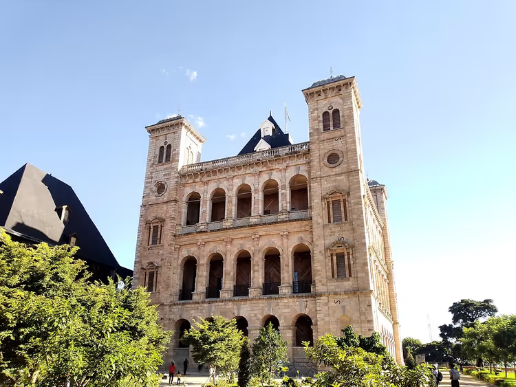
Antananarivo sits on hills, and the elevation changes are noticeable on every walk. The best view opens up from the highest point, where two palaces stand. Andafiavaratra now operates as a museum with a royal collection, and nearby rises the Rova, the former residence of Malagasy kings. The climb takes about half an hour, and in the heat it's a full-on hike: bring water and set out before noon.
 © Dalbergiaada · CC BY-SAPhoto: Dalbergiaada, CC BY-SA (https://creativecommons.org/licenses/by-sa/4.0), Wikimedia Commons
- How to get there: taxi or on foot from Analakely up the slope.
- Location: the historic core of the city, all viewpoints within walking distance of each other.
- Who it's for: those who want more than nature and want to understand the island's history.
3. Lemurs in the national parks
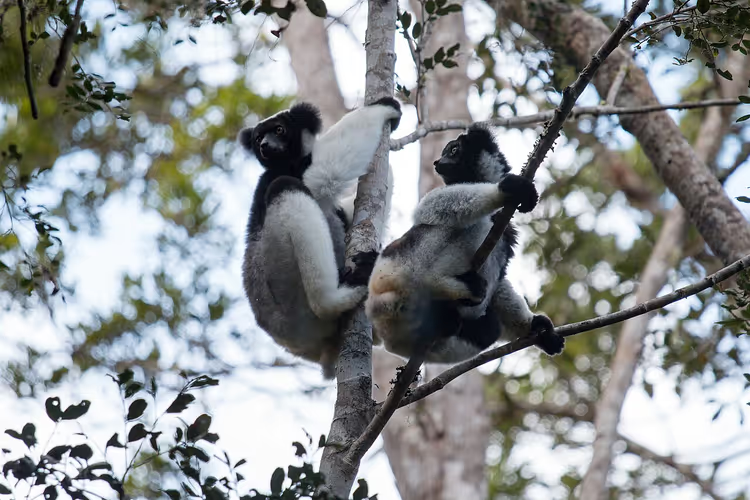
Almost all the local fauna is endemic: most animals and plants are found nowhere else on the planet. The island has several dozen lemur species, and the easiest place to see them is Andasibe-Mantadia National Park, three hours from the capital. That's where the indri lives, the largest surviving lemur.
 © Christophe Germain · CC BY-SAPhoto: Christophe Germain, CC BY-SA (https://creativecommons.org/licenses/by-sa/4.0), Wikimedia Commons
Park entry is paid, and trails are only done with a local guide hired on site, according to Madagascar National Parks. The walking trails are designed for different levels, from a short loop to a full day in the forest.
In the south of the country, lemurs and canyons await in Isalo National Park. A guide is mandatory there and is paid separately at the park office in Ranohira, so bring cash in ariary in advance. If long hikes aren't for you, private parks operate near the capital: Peyrieras Madagascar Exotic shows geckos, chameleons, and frogs, while a small lemur park (lemurspark.com) is set up for a short visit with kids.
- How to get there: a paved road leads to Andasibe-Mantadia, and you reach Isalo via Ranohira.
- Cost: each park has an entrance fee, and a guide is paid separately.
- Who it's for: those willing to get up before dawn to see animals in their natural habitat.
- The catch: there are no guarantees, lemurs live in the forest, not in an enclosure.
- See park tours and excursions on GetYourGuide
4. Ankaratra volcanoes
The Ankaratra highland region starts about an hour's drive from the capital. The plateau is dotted with craters and lakes, and the Tsiafajavona volcano rises above them all, standing more than two and a half kilometers tall. The volcanoes are considered extinct, but they occasionally make themselves felt with mild tremors. The trails here are easy in terms of terrain, but they require acclimatization: you will feel the altitude even on a short walk. It's best to take it easy on the first day.
- How to get there: car or jeep from Antananarivo, the drive takes about an hour.
- The catch: the weather changes within an hour, so warm clothes are needed even in the dry season.
5. Avenue of the Baobabs near Morondava
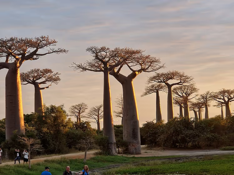
Baobabs grow in the west and south of the island, but the most famous view opens up on a dirt road near Morondava. Along it stand trees as tall as a nine-story building, and some of them are centuries old. The trunk works as a reservoir: it stores water inside, which is how the baobab survives months of drought and blooms even without leaves.
 © Hanay · CC BY-SAPhoto: Hanay, CC BY-SA (https://creativecommons.org/licenses/by-sa/4.0), Wikimedia Commons
- How to get there: a flight or a long overland journey to Morondava, then a dirt road.
- When to go: before sunset, when the light creates that postcard-perfect picture.
- The catch: in the rainy season the road gets washed out, making it harder to reach the trees.
6. Tsingy de Bemaraha stone forest
Tsingy de Bemaraha, a UNESCO World Heritage site, is a plateau of limestone needles. Trails, suspension bridges, and ladders run between them, while caves and canyons stretch underground. From the viewpoints you can see the entire stone forest at once, and people travel halfway across the country for this view. The climb up is not easy, with rocky ascents and narrow passages.
The park is open only in the dry season: during the rains the roads get washed out and access is closed (as of 09/2026, official park page).
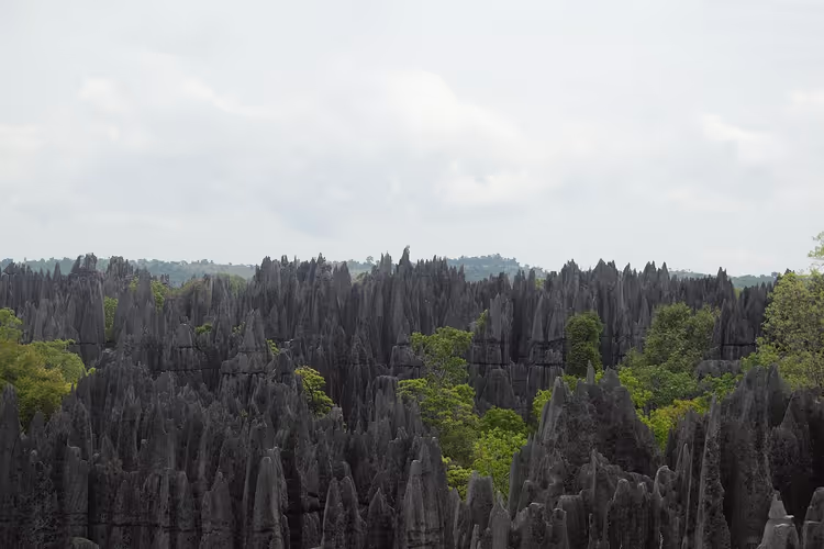 © Cactus0625 · CC BY-SAPhoto: Cactus0625, CC BY-SA (https://creativecommons.org/licenses/by-sa/4.0), Wikimedia Commons
- How to get there: from Morondava along a dirt road, part of the route is passable only by 4x4.
- Who it's for: those willing to make a long journey for geology.
- The catch: in the rainy season it's impossible to get inside.
7. Rainforests of the Atsinanana
The humid forests of the eastern slope, another UNESCO site, evolved in isolation for millions of years. They are home to plants and animals found nowhere else on the island. The forests are gradually shrinking due to logging, so routes follow designated trails, and hiring a guide is mandatory. Rain falls year-round, so a raincoat and waterproof shoes are needed even in the dry season.
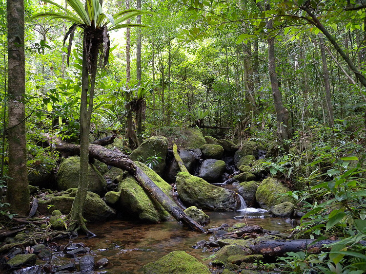 © Frank Vassen · CC BYPhoto: Frank Vassen, CC BY (https://creativecommons.org/licenses/by/2.0), Wikimedia Commons
- How to get there: east coast, most convenient with a stop in Andasibe.
- The catch: high humidity, mosquitoes, and year-round rain.
8. Nosy Be beaches and whale watching
The northern resort of Nosy Be is white sand and warm water. People come here to rest after the dusty parks, snorkel, and spend a couple of days without moving around. The island's infrastructure is well developed: from modest guesthouses to hotels with their own beach.
A separate reason to come is the whales. Humpback whales approach the archipelago from July to November, with the peak in August to October (as of 09/2026, operator on Nosy Be). Boat trips are run by local operators, and captains keep their distance from the animals and don't chase every pod.
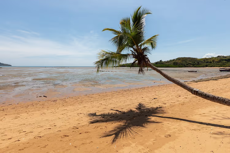 © Diego Delso · CC BY-SAPhoto: Diego Delso, CC BY-SA (https://creativecommons.org/licenses/by-sa/4.0), Wikimedia Commons
The island also has its own plantations: coffee, spices, and ylang-ylang grow in the volcanic soil, so farm tours take up half a day. Take one of these trips if you want to understand how the north of the country lives, not just the beach.
- How to get there: domestic flight from the capital or ferry from the port of Ankify.
- Where to stay: Nosy Be hotels on Trip.com
- Who it's for: those who want to end their route with beach and sea.
- The catch: during the rainy season, some boat trips are canceled.
Tours and tickets in Madagascar
Guided tours, skip-the-line tickets and activities — most offers can be cancelled free of charge.
See offers on GetYourGuideThe widget loads once you give your consent.
⁉️🤔 Frequently asked questions
Do I need a visa for Madagascar and how long is it issued for?
The visa is issued online before departure on the official portal, tourist only and single entry, for a maximum of 60 days (as of 09/2026, visa service website). Keep a printed confirmation and a return ticket with you: they are asked for at passport control. Processing takes several days, so don't leave it until the last evening before your flight.
When is the best time to go to Madagascar?
The dry season from April to November is the most convenient: dirt roads are passable, parks are open, and there are no downpours in the south (as of 09/2026, national parks website). Even in these months, bring a raincoat: on the eastern slopes it rains year-round. The rainy season closes some roads and access to the stone forest.
Can you travel around the island without a guide?
Formally yes, but the roads and signage are poorly maintained, and in most parks a guide is mandatory and hired at the entrance. It's more practical to take a car with a driver for the whole route and fly between distant points. That way the logistics stay with a local, and you spend your time on the places themselves, not on looking for a turnoff.
How long will this route take?
For the eight places in this guide, allow about two weeks. The capital and its surroundings take two days, the eastern forests another two, the west with the baobabs and the stone forest requires a separate week, and Nosy Be makes sense at the end as a beach break.
Where and when can you see whales?
Near Nosy Be, humpback whales are present from July to November, with the best months being August, September, and October (as of 09/2026, baleinesrandeau.com). Whales come to breed and nurse their calves, so the main rule is simple: don't disturb the animals and don't get too close to them.
In short: what to book
The matrix is simple. If you're short on time, stay in Antananarivo and take day trips to Andasibe. If you want baobabs and the stone forest, plan a separate week in the west with a flight to Morondava. If you're going for the sea and whales, put Nosy Be last, after the dusty parks.
Book domestic flights and park guides in advance: in the dry season there's less choice and prices are higher. Pay park entrance fees in cash in ariary; cards are not accepted everywhere. A supply of small bills will come in handy.

A small editorial team writing guides for independent travel. We travel ourselves, but we haven’t been everywhere, so we check prices, opening hours and how to get there against official sources.